


![]()
G P Wealthall, S F Thornton and D N Lerner
Groundwater Protection and Restoration Group,
University of Sheffield, UK
www.sheffield.ac.uk/gprg
Abstract
The ether oxygenates MTBE and TAME have been used in petroleum fuel formulations in the UK since the mid-1980s and have led to contamination of major aquifers with these chemicals, including the Chalk aquifer of southern England. An assessment is made of the controls on the fate of MTBE and BTEX compounds at a contaminated site on the Chalk aquifer, using a novel package of investigation methods. The approach involves initial conceptualisation of the LNAPL source term and dissolved phase plume, with further site characterisation using combined rock core and downhole geophysical fracture logging, vertical hydraulic profiling and multilevel sampling of vertical solute profiles to understand the distribution of contaminants and biodegradation processes in the aquifer. The study shows that contaminant fate and transport is controlled significantly by the fracture network, contaminant properties and recharge events, with LNAPL penetration to 18 m below the water table and the migration of a diving dissolved phase plume to a depth of 40 m and at least 115 m downgradient. The dissolved plume comprises a mixed MTBE/TAME and BTEX plume close to the site with a separate MTBE/TAME-only plume further downgradient.
Keywords Chalk aquifer; LNAPL; MTBE; BTEX, natural attenuation
This study describes the use of a range of methodologies to assess the transport and fate of petroleum hydrocarbons, released by the accidental spill of 55,000L of unleaded fuel from a retail filling station, in the Chalk aquifer in southern England. The fuel contains the ether oxygenates, methyl tertiary butyl ether (MTBE) and tertiary methyl amyl ether (TAME) at concentrations of 2.88% v/v and 1.65% v/v., respectively. Natural attenuation (NA) is an acknowledged remediation strategy for groundwater contaminated with benzene, toluene, ethylbenzene and xylenes (BTEX) compounds in petroleum fuel (Wiedemeier et al 1999). However, there is increasing interest in the environmental behaviour of ether oxygenates and the fate of these compounds in groundwater remains uncertain (Landmeyer et al, 1998; Schirmer and Barker, 1998). Groundwater surveys indicate that contamination of the major UK aquifers with MTBE has occurred in recent years (Environment Agency, 2000). There is, therefore, an urgent need to understand the behaviour of ether oxygenates in these aquifers for robust risk assessment and to develop appropriate investigation strategies that are suitable for this assessment in the complex aquifer settings found in the UK.
The Chalk is the most important aquifer in the UK. It is 99% CaCO3, with minor marl and flint layers but very low mineral oxide (MnO2, Fe(OH)3) content. The aquifer matrix has high porosity (ca. 30-45%) but low effective permeability, and the matrix pore water is essentially immobile. The matrix is dissected by fractures, which contribute typically only 1% of the aquifer porosity, but which have very high permeability and dominate groundwater flow in the system. The aquifer can be conceptualised as a dual-porosity system, with transport occurring primarily in fractures with high transmissivity and the bulk of groundwater being stored in the low transmissivity matrix. The aquifer is unconfined in the vicinity of the site and overlain by 7 m of drift deposits. The mean water table is ca. 20-22 m below ground level.
Methods
Initial conceptualisation
The subsurface distribution of petroleum hydrocarbons was evaluated using an existing network of observation and monitoring wells. This network includes 5 onsite boreholes (max depth 9 m) to characterise LNAPL distribution in the vadose zone and 8 monitoring boreholes (max depth 30 m) to evaluate the onsite and offsite migration of floating product and dissolved phase contaminants. These monitoring wells are located transverse to and along the plume axis and are screened over 12 m across the water table. Groundwater samples from these boreholes show dissolved phase contamination between 20-30 m depth, with a mixed oxygenate/BTEX plume close to the site and oxygenate-only plume further downgradient. However the network is insufficient to resolve the spatial and temporal variation in contaminant transport behaviour necessary to evaluate NA. This site model was updated with an analysis of the structural geology of the Chalk using published literature, which identified the regional structural trends and their potential influence on contaminant migration at the site.
Based on the initial conceptual model additional site investigation was undertaken that included the drilling of cored boreholes, hydraulic testing and installation of multilevel samplers (MLS) at locations upstream of the site (MW14) and along the plume flow path in the oxygenate/BTEX plume (MW15, 30 m downgradient) and oxygenate-only plume (MW16, 113 m downgradient). This programme was designed to obtain vertical profiles of aquifer lithology and fracture distribution, hydraulic properties and dissolved solutes. These data were used to identify the aquifer properties that control contaminant fate at this site and as input to a transport model for prediction of dissolved phase contaminant migration.
Vertical profiling of fracture network, hydraulic properties and solute distributions
The spatial distribution and properties of the fracture network (type, aperture, intensity and orientation) were measured using undisturbed rock core and downhole geophysical logging of monitoring boreholes prior to the installation of the MLS. Lithological and fracture logs were obtained from the rock core. A portable PID meter was also used for onsite measurement of volatile organic compound (VOC) distribution in the rock core. These logs were compared with in situ vertical profiles of fracture distribution obtained using caliper logs and Acoustic TeleViewer (ATV) and OPtical TeleViewer (OPTV) downhole imaging logs, with a resolution of 1 mm.
A double-packer system was used to characterise the aquifer hydraulic properties (transmissivity, storativity, hydraulic gradient), with a test-zone (inter-packer) spacing of 1 m for tests in the plume and 2 m below the inferred base of the plume. Prior to hydraulic testing the boreholes were developed using a submersible pump (ca. 9 m3 hr-1 for 2 hrs) to remove drilling fines from fractures and recover drilling fluid (mains water) from the aquifer. Most zones were tested using short-duration pumping tests (ca. 1-2 hours) except for low-permeability zones, which were tested using falling-head slug tests. In-situ groundwater head values were estimated for each test zone, relative to the open borehole head, to obtain profiles of hydraulic head in each borehole. Measurements of VOCs were also made with a PID meter periodically on groundwater samples collected during the pumping tests.
Vertical profiles of solute distribution were obtained from the MLS completions after the installation of a Continuous Multichannel Tubing (CMT) system, containing seven monitoring ports (Einarson, 2000). Monitoring intervals on the MLS completions were determined using profiles of VOCs (from rock core and pumping tests), relative transmissivity (from pumping test flow rate and relative drawdown), lithology and fracture intensity (from rock core and geophysical logs). The MLS completions were installed up to a depth of 55 m and the boreholes were completed using sand packs and bentonite seals. The monitoring intervals varied from 1-2 m in the plume wells and up to 7.6 m in the upgradient well.
Groundwater sampling and analysis
Groundwater samples were collected from the MLS completions at periodic intervals using dedicated inertial lift pumps. Unfiltered samples were analysed for pH, electrical conductivity, dissolved oxygen, Eh, alkalinity, total dissolved inorganic carbon, petroleum and other volatile/semi-volatile hydrocarbons, MTBE, TAME, tertiary butyl alcohol (TBA), tertiary butyl formate (TBF) and total organic carbon, whereas filtered (0.45_m) samples were analysed for Ca, Mg, Na, K, Fe2+, Mn2+, Cl, NO3, NO2, NH4, SO4 and S2-, using appropriate preservation and standard methods.
Results
Fracture network properties
The fracture network characterisation identified bedding-parallel fractures with a dominant ENE-WSW strike and dip of 2-29° to the SSE. There is also a subordinate bedding-parallel fracture set with E-W strike and N dip of 10-30°. High angled fractures include sets with a ENE-WSW or E-W trend and NNW dip of 30 to 80°, and sets with a NW-SE trend and NE dip of 35-75°. The mean fracture spacing for combined bedding-parallel and high-angled fractures is 0.23 m. Fracture porosity is estimated as 1.1%, assuming three orthogonal fractures sets, a range of block sizes determined from the fracture spacing data, and fracture aperture derived from ranges (see hydraulic properties below) obtained in the hydraulic tests. This porosity is similar to estimates from other studies (Barker, 1993).
Hydraulic properties
Aquifer transmissivity varies significantly with depth (Fig. 1), with values from <1 to >600 m2 d-1 that are typical for the Chalk aquifer (Barker, 1993). Hydraulic aperture (determined from the Cubic law approximation) forms a bimodal distribution with a ‘small’ aperture population of ca. 100 to 600 mm (mean and standard deviation of 153 and 73 mm respectively) and a ‘large’ aperture population of ca. 600-1900 mm (mean and standard deviation of 1388 and 317 mm, respectively). Groundwater velocity based on the hydraulic tests and assumed to reflect fracture flow, is 10-3 to 100 m d-1. There is no significant vertical hydraulic head gradient in the upper 20-45 m of the aquifer, indicating that there is no vertical flow component capable of inducing vertical migration of contaminants (Fig. 1). Below this depth the head profile is negative relative to the open borehole, indicating outflow in the open borehole. This correlates with the inferred location of a hardground at ca. 45 m bfl in MW14. An increase in transmissivity at this depth suggests that the hardground is a semi-confining layer, which limits vertical movement of groundwater, but still accommodates sub-horizontal movement of groundwater.
The transmissivity profiles reveal zones of higher hydraulic conductivity between 27-30 mbfl in the MLS borehole at 30 m from the site (MW15) and between 26-28 mbfl and 30-35 mbfl in the MLS borehole at 115 m from the site (MW16). Periodic monitoring shows that the water table elevation fluctuates by ca. 2 m and that the local groundwater flow direction (SSE) varies temporally by 10°.
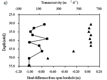
Fig. 1 a) MW14 transmissivity (closed circle) and hydraulic head (closed triangle) and b) MW15 transmissivity (closed circle) and hydraulic head (closed triangle) plus MW16 transmissivity (open circle) and hydraulic head (open triangle).
Dissolved phase contaminant distributions
The distribution of selected organic contaminants in groundwater 30 m and 115 m from the site is shown in Fig. 2. Contaminants occur between 20-40 m depth below the filling station forecourt level (mbfl) at each location, but with marked heterogeneity in their distribution. Diesel range hydrocarbons (DRHC) and BTEX in the fuel mixture are restricted to a depth of 20-33 mbfl and are below detection limits at 115 m from the site. Contamination with MTBE and TAME extends to a greater depth than with the DRHC or BTEX (Fig. 2a-e), but concentrations of the oxygenate compounds are lower in the downgradient MLS (Fig. 2f).
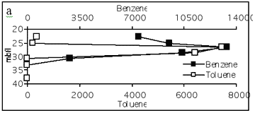
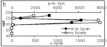
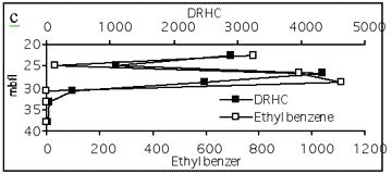
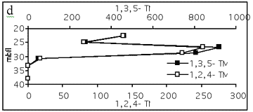
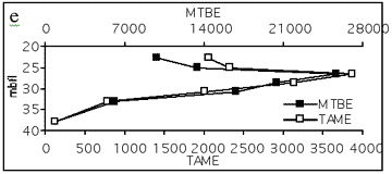
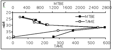
Fig. 2 Organic contaminant profiles for MLS boreholes 30m from site (a-e) and 115m from site (f)
Discussion
Fractures form preferential pathways for the migration of LNAPL and dissolved phase contaminants in the Chalk aquifer. The main controls on the subsurface geometry of the LNAPL source term are transverse spreading of the LNAPL, penetration to below the water table, and redistribution within the vadose zone due to water table fluctuations (smearing). The high concentrations of dissolved phase contaminants at 40 m depth close to the source and negligible vertical hydraulic gradient imply penetration of LNAPL below the water table along vertical fractures. An ‘indirect’ estimate of the depth of LNAPL penetration, using a plume base inverse projection (Fig. 3) indicates that the base of the source term may be 37.0 to 38.8 mbfl, equivalent to16.5-18.3 m depth below the water table. Adopting a simple 1-D force balance model (Hardisty, 1998), fuel density of 750 kg m-3 and negligible capillary forces (due to large fracture apertures, ca. 1 mm), indicates that a 5.5 to 6.3 m height of LNAPL above the water table is required to produce the inferred penetration. The dominant NE-SW to E-W trending high angled fractures suggests that LNAPL may be distributed transverse to the plume orientation, producing a more widely dispersed source zone. This is also implied by inverse projection of the plume envelope, based on changes in flow direction, which suggests a source zone width of 40-60 m. Direct evidence is not, however, available to define the true source width. Buoyancy forces may also redistribute LNAPL, particularly in the higher angled fractures and, when present below the water table, lead to trapping of LNAPL. Water table fluctuation may also act as a mechanism for pumping LNAPL both vertically and laterally.
As evidenced in many site investigations, limited direct information is available on the geometry and mass distribution of the source term. However, the fracture porosity represents ca. 1% of the bulk rock volume and it is clear that even small volumes of LNAPL may pervade the fracture network.
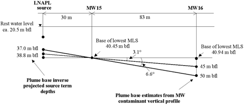
The distribution of dissolved phase contaminants in the aquifer is controlled by site geology, aquifer hydrogeology, contaminant properties and groundwater chemistry. Plume migration depth appears to be controlled by the regional structural dip of ca. 1-3°, based on the structural analysis and contaminant distribution. The semi-confining hardground identified in the upgradient MLS (MW14) may locally limit the depth of plume migration in the aquifer. The hardground is estimated (assuming 3.14° dip) at ca. 64 m bfl at the location of MW16. The depth of aquifer contamination is also controlled by LNAPL penetration below the water table. This vertical migration of product will form a deeper source zone for dissolved phase contaminants in addition to residual product present in the vadose zone.
Contaminant fluxes from the site and the vertical distribution of contaminants in the aquifer are strongly controlled by water table fluctuations and fracture transmissivity. Contaminant concentrations and fluxes are higher in fractures with higher transmissivity. This flux varies markedly in a vertical sense due to significant variations in fracture transmissivity through the plume profile and could not be identified by conventional long screen monitoring wells. Episodes of higher contaminant flux from the site are associated with recharge events that increase the water table elevation and allow dissolution of fresh product in source zone fractures that are otherwise not accessible.
Two superimposed plumes are present in the contaminated aquifer. These are a mixed plume of DRHC, BTEX, MTBE and TAME extending from the site to 40 mbfl and 30 m downgradient, and a plume of MTBE and TAME, extending from 40-115 m downgradient of the site to at least 41 mbfl. This distribution reflects the early release of the more soluble oxygenates from the LNAPL. Both MTBE and TAME are transported further from the site, as shown in other studies (Landmeyer et. al.; 1998; Schirmer and Barker, 1998). The leading edge of the oxygenate/BTEX plume is not known, but is between 30 m and 113 m from the site, whereas the leading edge of the oxygenate-only distal plume is greater than 113 m. The distribution of redox-sensitive species in groundwater indicates that biodegradation of the BTEX and other aromatic compounds is occurring by aerobic respiration, NO3-reduction, Mn(IV)/Fe(III)-oxide reduction and SO4-reduction, whereas MTBE may be aerobically biodegraded to TBA (Wealthall et. al., 2001). A mass balance suggests that over 90% of the contaminant mass within the saturated zone could be present, dissolved or sorbed within the aquifer matrix, under worst case conditions and that diffusion into the aquifer matrix is an important natural attenuation mechanism limiting the migration of dissolved phase contaminants.
Conclusions
The methodology used to characterise contaminant fate and transport at this site provides an integrated approach to the assessment of NA in dual-porosity aquifers. The techniques allow key aquifer properties that control transport to be estimated on a site-specific basis, the improved resolution of contaminant distribution and biodegradation processes, development of better conceptual models for these aquifers and in turn, more reliable risk assessment.
Acknowledgements The authors gratefully acknowledge the sponsorship of this research by TotalFinaElf UK Ltd. We thank QDS environmental consultants for assistance with field activities at the research site. We also acknowledge the support of CL:AIRE and the Environment Agency in the completion of this work.
References
Barker, J. A. (1993). Modelling groundwater flow and transport in the Chalk. Chapter 4 in The Hydrogeology of the Chalk of North-West Europe. Downing, R. A., Price, M and Jones G. P.(editors). Clarendon Press: Oxford.
Einarson, M. D. (2000). Comparison of Eight Innovative Site Characterization Tools Used to Investigate an MTBE Plume at Site 60, Vandenberg Air Force Base, California. Report downloaded from www.solinst.com, 13 pages.
Hardisty, P. E., Wheater, H. S., Johnston, P. M. and Bracken, R. A. (1998). Behaviour of light immiscible liquid contaminants in fractured aquifers. Geotechnique. 48 (6) 747-760.
Environment Agency (2000). A review of the current MTBE usage and occurrence in groundwater in England and Wales. Environment Agency R&D publication no. 97.
Landmeyer, J.E., Chapelle, F.H., Bradley, P.M., Pankow, J.F., Church, C.D. and Tratnyek, P.G. (1998). Fate of MTBE relative to benzene in a gasoline-contaminated aquifer (1993-98). Ground Water Monitoring and Remeidiation, 18, 93-102.
Schirmer, M. and J.F. Barker (1998) A study of long-term MTBE attenuation in the Borden Aquifer, Ontario, Canada. Ground Water Monitoring and Remediation, 18, 113-122.
Wealthall, G. P., Thornton, S.F. and Lerner, D.N. (2001). Natural attenuation of MTBE in a dual porosity aquifer. In: 6th International Symposium on In situ and on-site bioremediation. San Diego, 4-7 June. Batelle Press (in press).
Wiedemeier, T.H., Rifai, H.,S., Newell, C.J. and Wilson, J.T. (1999). Natural attenuation of fuels and chlorinated solvents in the subsurface. Wiley & Sons. USA, pp617.