

3 Case Study
The following is a case study of multilevel completions at a petrol station in the United Kingdom where leaking petrol penetrated a fractured rock aquifer. More information can be obtained from CL:AIRE (2002) and Wealthall et al (2001).
3.1 Background
The site was an active petrol station at which approximately 55,000 L of gasoline containing the ether oxygenates methyl tertiary-butyl ether (MTBE) and tertiary methyl-amyl ether (TAME) were released from a leaking underground storage tank in 1999. The spill penetrated a thin mantle of drift and entered underlying chalk bedrock, which comprised a major aquifer system in southern England. Initial investigations were undertaken by a contractor to remove free product, and to assess the downgradient extent of the plume.
The site owner was under considerable pressure from the regulatory authority to remediate the plume using pump and treat due to a perceived risk to a down gradient water supply well. The installation of three strategically placed multilevel systems provided sufficient detailed information to strongly support an argument that the risk to the downgradient well could be satisfactorily managed by monitored natural attenuation.
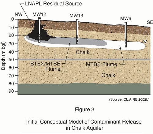
3.2 Development of an Initial Conceptual Model
Earlier work at the site involved the completion of boreholes in the vadose zone and the completion in the saturated zone of long screened (12m) wells straddling the water table to maximum depths of approximately 30m below ground surface (bgs). These wells were only suitable for the extraction of free product and gross delineation of the plume. They did not provide sufficient information about the groundwater flow system, plume geometry and distribution or fate of the contaminants to develop a coherent groundwater management plan for the site.
The site owner secured the services of the Groundwater Protection and Restoration Group at the University of Sheffield. The objectives of the work were to assess the fate and transport of the gasoline contaminants and to investigate the feasibility of managing the contamination through monitored natural attenuation.
An initial conceptual model (seeFigure 3) was developed based on borehole information, groundwater sampling and a review of the literature of previous investigations in the chalk aquifer.
The model depicts approximately 7m of drift overlying chalk bedrock. The water level is located at approximately 20-22 m below ground surface. A BTEX/MTBE plume was identified proximal to the source area. Further downgradient the plume is composed predominantly of MTBE. The conceptual model identified data gaps which needed to be filled in order to meet the objectives of the investigation. Additional required information included: the nature and extent of the source; the spatial variation in aquifer properties; further characterization of the site geology and the vertical and horizontal extent of the contaminant plume.