Solinst Eureka Success Cases
![]()
Solinst Eureka
2113 Wells Branch Pkwy, Seomra 4400
Austin, TX, Stáit Aontaithe Mheiriceá
78728
Teil: +1 512-302-4333
Facs: +1 512-251-6842
ríomhphost: [email protected]

Eureka Probes used in Dangerous Environments
The University of Texas/Dallas is developing a method to assess environmental sites that might be dangerous or challenging for humans to enter, such as after a hurricane, oil spill, chemical leak, or other disasters. They have designed an autonomous, integrated robotic system using an unmanned boat, unmanned aircraft, and ground robots. These devices can access and navigate areas that are difficult to reach and dangerous for humans, such as aquatic environments.

SFPUC: Solar Charged Continuous Monitoring in Rugged Conditions
As part of the Alameda Creek Aquatic Resources Monitoring Program, near the town of Sunol, CA, the San Francisco Public Utilities Commission (SFPUC) operates a rotary-screw trap (RST) and fyke trap. Trapping data is used to document the downstream movement patterns of fishes, and age-class-specific relative abundances of juvenile Oncorhynchus mykiss, in the southern portion of upper Alameda Creek. The different trap tyles allow for monitoring over a wide range of conditions, with the screw trap fishing at higher flows (about 25 to 400 cfs) and the fyke fishing at lower lows (about 10 to 40 cfs).

Scientists Monitor Water in Everglades with Hydrostation-in-a-briefcase
Scientists at the Everglades Science Center are studying the flow of freshwater into Florida Bay and the impact the diversion of water has had throughout the Everglades ecosystem. Their studies include corals, seagrasses, mangroves, game fishes, crocodiles, wading birds, White-crowned Pigeons and many ecosystem-level studies. Their experiments link changes in freshwater flow to decreased plant production and subsequent loss of small fishes. These are vital parts of the ecosystem, making up the food base for many higher predators such as game fishes, crocodilians, wading birds and birds of prey.

Maintaining Water Quality in a Formerly Flammable River
Buffalo Niagara Waterkeeper has been a guardian of Western New York’s fresh water for over 30 years. They work with partners, municipalities, and elected officials to ensure the health and protection of New York State’s Great Lakes and shoreline ecosystems. Waterkeeper has improved water quality through volunteer programs, water quality monitoring, restoration projects, and educational outreach.

BYU: After a Mega Fire, How Are Waterways Impacted by a Wildfire?
Utah continues to experience larger and more severe fires. Scientists from Brigham Young University are working to understand how these fires impact water flow, sediment, and TDS in the Spanish Fork watershed.

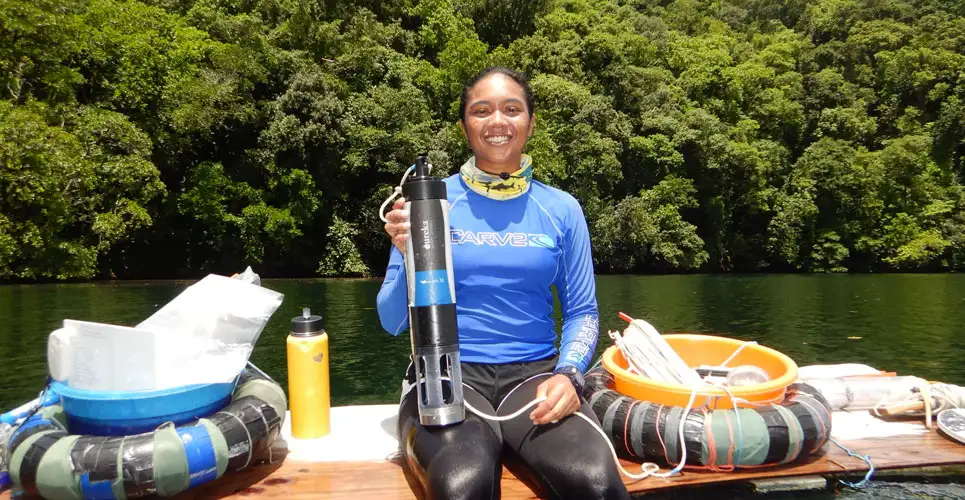
UT: Robots used to Analyze Aquatic Environments
The University of Texas/Dallas is developing a method to assess environmental sites that might be dangerous or challenging for humans to enter, such as after a hurricane, oil spill, chemical leak, or other disasters. They have designed an autonomous, integrated robotic system using an unmanned boat, unmanned aircraft, and ground robots. These devices can access and navigate areas that are difficult to reach and dangerous for humans, such as aquatic environments.

NPS, Eastern River and Mountains Network
Since 1999, the National Park Service has conducted long-term ecological monitoring designed to identify and monitor conditions of their highest priority natural resources. The Eastern Rivers and Mountains Network is one of 32 networks formed to implement this integrated monitoring program which is tailored to specific needs of parks located in similar environmental settings. Due to its importance as a natural resource and as an important element of visitor experience, water-quality was selected as one of 12 core NPS natural resource inventories for which baseline data were collected system-wide.

Remote Monitoring for Early Warning of Water Pollution Events
In order to provide continuous water-quality information for waterhead sheds in the Allegheny River Basin, the Evergreen Conservancy collaborated with the Indiana County Emergency Management Agency in Indiana, Pennsylvania to install and maintain a cellular telemetry water monitoring system in Indiana County. The telemetry systems are located at five sites to alert staff in the event of spills, leaks, accidents, holding pond failures and/or contaminated nonpoint-source runoff.

Turbidity Monitoring Established Baseline Data Prior to Construction Activities
The Pono Kai Seawall is located on the eastern coastline of the island of Kaua’i. It was significantly damaged from years of exposure to high tides, heavy rains, and pounding surf. The seawall was to be repaired by constructing a sheet pile wall with a rock toe and adding beach nourishment. However, the repair project could result in suspended sediment that might degrade water quality in the area around the project site, possibly causing harm to wildlife and vegetation. During the construction, water quality had to be continually assessed to determine any degradation of water quality.

Vertical Profiler Provides Continuous Monitoring in High Hypolimnetic Sulfide Concentrations
The Yigal Allon Kinneret Limnological Laboratory (KLL) is located on the NW shore of Lake Kinneret (Sea of Galilee). This lab monitors major environmental factors that determine the state of the lake and conducts limnological research aimed at understanding how present and future conditions might affect the ecosystem of the lake and the quality of its water.

Successful Continuous Water Quality Monitoring in Extreme Bio-Fouling Conditions
Bio fouling (or biological fouling) is the accumulation of microorganisms, plants, algae, or animals on wetted surfaces. Ajman Municipality, Environment Department, Natural Resources Conservation Section, had installed six water quality monitoring stations. ELARD served as the integrator for monitoring creeks and water surfaces in the city of Ajman, United Arab Emirates, and consistently checked for water pollution and challenging environmental variables.

High-Resolution Temporal Monitoring of an Arid, Urban Lake
Tempe Town Lake is an artificial lake located near the urban core of Tempe, AZ, derived from the damming of the Salt River. It was constructed in 1999 primarily for the use of recreation such as fishing and boating. This lake is Arizona’s second most visited tourist attraction that generated a cumulative economic impact of over $1.5 billion dollars since its creation, so it is critical to monitor and maintain its viability. Since 2005, it has been subject to long-term water quality monitoring. Dissolved oxygen levels are generally above 5 mg/L, suggesting the lake is not eutrophic. The lake also trends alkaline, with an average pH around 8, likely due to its high productivity and carbonate-poor basement rock.

Water Reuse Model Research
A University of Nevada Las Vegas research team wanted to create an accurate model for best practices in water reuse. David James, Ph.D., and his research students performed water flow research at Lake Arrowhead in California. This lake is 782 acres in size, 185 ft deep, and has an elevation of 5,174 ft. The research team used tracers and water probes to collect water flow data.

Braiteoirí Cáilíochta Uisce Sraith Manta
Solinst Eureka cuireann an rogha is mó de theicneolaíochtaí braiteora cáilíochta uisce sa tionscal ar fáil. Mar sin, sa bhreis ar chumraíochtaí caighdeánacha, is féidir gach tóireadóir a shaincheapadh do d’fheidhmchlár sonrach. Roghnaigh braiteoirí de do rogha féin chun tóireadóirí níos mó a líonadh go hiomlán, nó cuir pacáiste ceallraí leis chun tóireadóir a thiontú ina fheiste logála.

Tóireadóir Cáilíochta Uisce Triméadar Manta
Tá braiteoir amháin ar bith* ón liosta Paraiméadair Braiteora sa Trímhéadar , chomh maith le braiteoirí teochta agus doimhneachta (tá an dá cheann roghnach). Mar shampla, d'fhéadfadh cumraíocht Trímhéadair a bheith ina moirtiúlacht, teocht, agus doimhneacht. Sampla eile d'fhéadfadh DO agus teocht a bheith ann.

EasyProbe: Sondaí Cáilíochta Uisce
Is monatóir cáilíochta uisce ardfheidhmíochta agus cost-éifeachtach é an EasyProbe , ó Solinst Eureka. Tá sé oiriúnach le haghaidh seiceála ar an toirt, teileamaitriú cianda, oideachas, taighde, dobharshaothrú, agus níos mó. Cuimsíonn an EasyProbe20 braiteoirí le haghaidh teochta, ocsaigine tuaslagtha, seoltachta, agus pH, agus cuireann an EasyProbe30 braiteoir moirtiúlachta leis. Tá il-bhraiteoirí Eureka aitheanta as a n-iontaofacht, le barántas trí bliana a chlúdaíonn gach braiteoir, agus tá na costais chothabhála is ísle sa tionscal acu.
Related Products

Logáil Sonraí Leibhéal Uisce, Teocht & Seoltachta
Déanann an Levelogger 5 LTC luaineachtaí leibhéal an uisce, teocht agus seoltacht a thomhas agus a logáil. Tá sé cláraithe chun taifeadadh ag eatraimh chomh minic le 2 shoicind. Áirítear leis ceallraí 8 mbliana, cuimhne do 100,000 tacar léamha, agus tagann sé i 6 raon brú. Soláthraíonn sciath saor ó PFAS (istigh agus amuigh) friotaíocht níos fearr in aghaidh creimeadh agus scríobtha.

Méadar TLC – Tomhais Teocht, Leibhéal & Seoltacht go Cruinn
Soláthraíonn Méadar TLC tomhais teochta agus seoltachta cruinne, cobhsaí, a thaispeántar ar thaispeántas LCD áisiúil le haghaidh léamh éasca. Léitear leibhéal uisce statach agus doimhneacht na léamha ó théip chomhréidh Solinst, atá marcáilte go beacht le léasar gach mm nó 1/100 troigh. Tá faid téipe ar fáil suas le 300 m (1000 troigh).