

![]()
G P Wealthall, S F Thornton and D N Lerner
Groundwater Protection and Restoration Group,
University of Sheffield, UK
www.sheffield.ac.uk/gprg
Hydrogeology
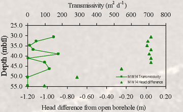
The vertical hydraulic head gradient in the upper 20-25 metres of the saturated Chalk aquifer at the site is insignificant. Below this depth the head profile observed in the upgradient well (MW14), is negative relative to the open borehole, indicating outflow in the open borehole. This observation correlates with the inferred location of a hardground at a depth of ca. 45 metres below forecourt level (mbfl) in MW14
The horizontal groundwater gradient ranges from 0.0016-0.0031 (m/m)
The local ground water flow direction also varies temporally between 150-160° (SSE) and is sub-parallel to the regional groundwater flow direction of around 140° (SSE-SE)
The water table elevation fluctuates temporally by ca. 2 m