
Hydrology and Hydrogeology in the '90s
American Institute of Hydrology, 1991
Pp. 126-134
J.G. Pianosi
Solinst Canada Ltd.,
35 Todd Rd., Georgetown, Ontario
T.R. Weaver
Institute for Groundwater Research
Department of Earth Sciences
University of Waterloo
Waterloo, Ontario
INTRODUCTION
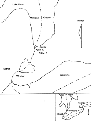
Two sites in southern Ontario were studied through instrumentation of boreholes with Waterloo Multilevel Monitoring Systems. These sites are located approximately 7 km (4.3 miles) apart and lie between Sarnia to the northwest, and Petrolia to the east in lambton County, Ontario, Canada (figure 1). Multilevel monitoring devices were installed to provide detailed vertical correlation of chemical and pressure data to assist in the determination of the groundwater regime of the area,
Figure 1. Site location map
GEOLOGY
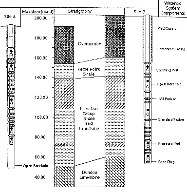
The Sarnia area is located on the eastern edge of the Michigan Basin. Stratigraphically, the area comprises flat-lying or gently dipping Cambrian, Ordovician, Silurian and Devonian sedimentary deposits. The formations of interest at each site include the upper bedrock formations of the Paleozoic sequence in the region (figure 2). The uppermost zone monitored at each site is completed in the Kettle Point Formation, a black, organic-rich shale with some fracturing noted in the core. The Kettle Point. Formation is relatively thin in this area and is underlain by the Hamilton Group, comprised mainly of soft, grey shales and limestones at each site. The lowest monitoring zone at each site is open to the top of the Dundee Formation, an oil-bearing limestone from which petroleum is produced in the surrounding area, Underlying the Dundee Formation is the Detroit River Group, a dolomitic limestone used as a waste disposal formation during the 1960's and 1970's. A 40 meter (130') thick blanket of glacial till overlies the Kettle Point shale across the study area,
Figure 2. Stratigraphy and multilevel system installation designs.
HISTORICAL DATA
Although few studies have investigated the flow regime and chemistry of groundwater in the bedrock formations of the Sarnia area, historical records provide insight into the behavior and characteristics of fluids from these formations. Records of petroleum seeping into local streams and ponding on the surface of clay till (Harkness,
1951) in the region indicate that fluids must have migrated vertically upward from the oil-bearing formations through the overlying shales into the till. Transport of saline formation water is also suspected to have occurred simultaneously with petroleum transport. The first wells drilled in the region in the 1860's (Harkness, 1951) also indicated strong upward gradients from the oil-bearing Dundee Formation through the overlying shales and till to the ground surface. One of the preliminary issues to be addressed by the installation of these multilevel bedrock monitoring wells is the degree to which these gradients have dissipated since oil production began. Additionally, geochemical information should provide insight on the historical movement of fluids through the shales.
Records of the disposal of liquid industrial wastes to the Detroit River Group also provide information of the physical hydrologic regime of the bedrock formations in the study are & The Detroit River Group received a variety of liquid industrial wastes between 1958 and 1975. These wastes included spent refinery caustics, phenols, acids, organics and ammonia and were injected into this formation under pressure (McLean, 1968). During injection, records of waste breakouts in stratigraphically higher units indicated that vertically upward gradients were established when the system was pressurized. Between 1975 and 1990, disposal in this formation was limited to gravity drainage of waste liquids at a few wells in the Petrolia area, These fluids were predominantly oil-field brines from deeper in the stratigraphic section. In 1990 new disposal wells were installed into the Detroit River Group in the Petrolia and Oil Springs area. Waste oil-field water from petroleum production from the Dundee and Detroit River Group are currently being introduced to the Detroit River Group under gravity drainage. Again, the wells installed in this study should provide insight on the degree to which high pressures established during the injection phase of waste disposal have dissipated.
Studies of groundwater chemistry in this region have primarily been limited to the overlying glacial till formations (Desaulniers et al, 1981: Ruland et al, 1991 among others). Groundwater chemistry of Silurian and deeper bedrock formations have been performed by Frape et al, 1989 and the groundwater chemistry of the oil-field water from the Dundee Formation is currently being investigated (Weaver et al, in prep.). Little information on the groundwater chemistry of the shales separating the overlying tills from the underlying oil-bearing units has been collected, however, and the wells instrumented as part of this research are providing data through time on the current groundwater chemistry in these shales.
Other than the ongoing research described in this paper, the only other study investigating the groundwater
head and chemistry of the Hamilton Group shales and limestones is part of the monitoring of a deep (760m/2500')
multilevel monitoring well installed by the Ontario Ministry of the Environment in the City of Sarnia. Initial findings from this well are presented by Raven and Boulanger, 1990.
MULTILEVEL MONITORS
General Description
The multilevel monitoring device chosen for this study was the Waterloo Multilevel Monitoring System. It is a system specifically designed and engineered to obtain data from many elevations in a single bedrock borehole. It is of modular design, and as such, is installed in much the same way as a typical PVC standpipe piezometer. In addition, the Waterloo System has the option of including dedicated sampling pumps and pressure transducers, and multiple packers to seal unmonitored zones, thus making it particularly useful for this project.
The system is comprised of stainless steel monitoring ports, and permanent, positive-seal packers built into a PVC casing string. Individual tubes and cables extend within the casing string from each port to the surface. This provides monitoring access to each zone isolated by the Waterloo packers. The small diameter tube design of the system reduces purge volumes and lag time effects, making it very applicable for monitoring and sampling in low hydraulic conductivity formations.
The Waterloo Packer
One of the most important components of the Waterloo Multilevel System is the self-inflating packer which provides a continuous, positive seal within the borehole annulus. The packer is composed of layers of flexible gum rubber, woven KevIar and Dowell expansion sealant over a PVC screen section (figure 3).
Figure 3. Waterloo system components.
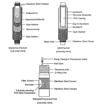
The backbone of the packer - a length of slotted PVC screen, is covered with a molded Dowell expansion sleeve. The Dowell is a unique, hydrophilic material which expands by simply absorbing water from inside the casing string. The Dowell sleeve is covered with a layer of gum rubber to retain the sealant material. A woven KevIar wrap is installed over the gum rubber. While designed to allow expansion, the strong Kevlar affords protection against rupture due to possible overexpansion into a large void or fracture, or against a sharp protuberance in a borehole. A final layer of gum rubber is used to cover the Kevlar and provide a soft pliable outer layer capable of conforming to an irregular borehole wall.
In order to provide a greater percentage of sealed borehole, while limiting costs, special infill packers were provided by Solinst Canada. These packers have a PVC casing backbone, a partial geofabric sock, a gum rubber outer layer, and are filled with dry, granular bentonite (figure 3). Two small holes on either end of the packer allow groundwater to enter the packer. The geofabric acts as a conduit for the water to come in contact with most of the bentonite. A short gap in the geofabric is left to prevent any short circuiting of water through the packer. Inflation of the infill packers starts as soon as the packers are lowered to a point below static water level. The inflation process is timed to take place after the Waterloo packers have inflated.
As the Waterloo packer is designed of relatively inert materials, and only the gum rubber comes in contact with the groundwater being monitored, there is no concern about sample degradation as there is when bentonite or grout are used as seals. The infill packers have very limited contact with groundwater, but in this study were separated from the sampling zones above and below by Waterloo type packers.
After installation of a Waterloo system, water is added to fill the casing string. This water passes through the PVC screen and is absorbed by the Dowell in each packer, causing simultaneous packer expansion. The packers expand with time, as long as there is water adjacent to them in the casing string. Typically, it takes 24 - 48 hours for a standard Waterloo packer to effectively seal a borehole. Lab tests have proven the packers to be effective in separating intervals with pressure differentials of up to 689.5 kPa (100 psi).
The effectiveness of the Waterloo System packer in ensuring a tight, reliable seal within a borehole, without the need to monitor or reinftate the packer, was a major factor, both in technical and cost considerations for this project
Monitoring Ports
The monitoring ports of the Waterloo System are made completely of 316 stainless steel. Access to the monitoring interval is through a 9.5mm (.375") inlet tube which is covered by a double wrap of 75 micron (200 mesh) stainless steel screen (figure 3).
Coaxial polyethylene tubing connects stainless steel positive displacement gas drive pumps right at the monitoring ports for groundwater sampling. These pumps are very reliable, and require no maintenance or adjusting after installation. They provide fairly low pumping rates (1 to 1.5 liters per minute/.25 to 33 gpm), which are quite acceptable considering the small volume of groundwater in the tubing to be purged, and the low flow rates in the monitoring zones in this study.
Dedicated vibrating wire pressure transducers were installed onto separate stainless steel ports within each monitoring zone. Heavy duty direct-burial 4-conductor cable extends from each transducer to the surface, allowing either manual of datalogged readings of pressure and temperature to be taken in each zone.
METHODOLOGY
One multilevel bedrock monitoring well was installed at each research site (Sites A and B on figure 2). A Longyear 38 drill rig with a tricone bit was used to drill to the till-bedrock interface (approximately 40m/130'). The overburden was then cased off, the casing cemented in and a blow-out protector installed on the rig for bedrock drilling. Bedrock was cored using a 76mm (3") diamond drill bit and NQ casing and core barrel. Below the top 3 meters (10') of shale, full core recovery was achieved from each borehole. Each well was drilled to a depth of 143 meters (469'), extending approximately 2 meters (6.5') into the oil-bearing Dundee Formation and the stratigraphy encountered during drilling was similar at each site.
After each borehole was completed, the diameter was tested using a down-hole dummy (74.6mm/2.94" diameter). Geophysical logging of the borehole was not done due to concern regarding the degree of competence of the shale comprising the majority of the open portion of the borehole. Once the borehole was tested, the drill rig moved off site and the Waterloo Multilevel System was installed.
The final construction of each monitoring well is shown in figure 2. Due to the potential for high pressures to be encountered at depth, many packers were used in each well. Consequently, approximately 25% of the uncased portion of the borehole at Site A, and approximately 22% of the borehole at Site B. was sealed with packers. Every monitoring zone in each well is equipped with a permanently dedicated pressure transducer and groundwater sampling device, enabling easy pressure monitoring and groundwater sample collection. A readout box and ohm-meter are all that is needed to take pressure measurements, and a control box and pressurized gas source are all that is required to collect groundwater samples. No decontamination procedures or lowering of equipment down-hole is required. As such, one person can easily and rapidly take readings and collect samples without assistance.
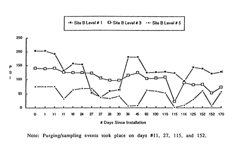
Transducers were calibrated to the standing water level in each borehole after installation but before the packers had sealed, to provide reliable zero readings for each transducer. Pressure measurements taken over the three weeks following installation indicated minimal release of drilling fluids into the bedrock. Instead, purging to remove drill fluids initiated return to normal hydrostatic levels. Figure 4 illustrates a decrease in pressure in each monitoring zone over time, with the most marked changes brought on by early purging is ampling events. The different rates of recharge for each zone shown in figure 4 are good indication that the packers between monitoring zones are providing effective seals. Transducers with ranges from 0 - 689.5 kPa to 0-1,723.75 kPa (0-100 psi to 0-250 psi) were used in each borehole with the range increasing with increasing depth. Such large range transducers were used due to the limited information of the pressure regime of the formation and a record of high pressures within the lower Hamilton Group shales in the Sarnia borehole Raven et al, 1990). Pressure measurements are corrected for temperature and the calibration factor appropriate to the measured value. Barometric pressure corrections are considered inappropriate considering the depth of the monitoring zones and the apparent low-permeability of the system.
Figure 4. Site B hydraulic pressure recovery data.
PRELIMINARY RESULTS AND INTERPRETATIONS
Both Multilevel bedrock monitoring wells installed as part of this research project are completed in very low permeability geological formations. Consequently, the data presented here indicate the initial response of these wells to installation and purging. None of the pressure measurements presented can be taken to represent equilibrium conditions in the formations monitored. On-going monitoring of pressures, and sampling and chemical analysis will provide substantial detail required to determine the hydrologic regime of the area, and to better define the role of the shales in controlling interaction between the overlying glacial deposits, and the underlying bedrock formations on the Sarnia area.
REFERENCES
Brigham, RJ., 1971. Structural Geology of Southwestern Ontario and Southeastern Michigan. Ontario Department of Mines and Northern Affairs, Petroleum Resource Section, Paper 71-2, 1 l0p.
Desaulniers, D.E., J.A. Cherry and P. Fritz, 1981. Origin, Age and Movement of Pore Water in Argillaceous Quarternary Deposits at Four Sites in Southwestern Ontario. Journal of Hydrology, v.50, pp.231-257.
Frape, S.K., P. Dollar, B. Sherwood Lollar and R.H. Mcnutt, 1989. Mixing of Saline Basinal Fluids in Southern Ontario: Implications of Rock-Water Interactions, Hydrocarbon Emplacement and Canadian Shield Brines. Proceedings of Water-Rock Interaction,WR1-6, Malvern, U.K., Miles (ed), 1989, Balthema, Rotterdam, pp. 223-226.
Harkness, R.B., 1951. Ontario's Part in the Petroleum Industry. Canadian Oil and Gas Industries, Feb. and March, 1951, pp.1-8.
McLean, D.D., 1968. Suhsurface Disposal of Liquid Wastes in Ontario. Energy and Resources Management, Petroleum Resources Section, 91p.
Pianosi, J., and D. Belshaw, 1990. The Waterloo Multilevel Groundwater Monitoring System. Proceedings of the 7th National Conference on Hazardous Wastes and Hazardous Materials, St. Louis, Missouri, pp.54-57.
Raven, K.G., D.W. Lafleur, and R.A. Sweezey, 1990. Monitoring Well into Abandoned Deep-well Disposal Formations at Sarnia, Ontario. Canadian Geotechnical Journal, Vol.27, No.1, pp.105-118.
Weaver, T.R., S.K. Frape, and J.A. Cherry, in prep.